


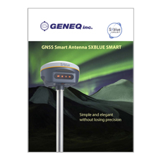
GNSS Smart Antenna / RTK receiver SXblue Smart
- SXblue - SMART
- Multi-Frequency
- Built-in IMU Tilt sensor
- UHF Radio: 410 – 470MHz
- 4G/LTE GSM Module
The SXblue SMART antenna is a rugged and versatile Multi-Frequency GNSS RTK receiver with built-in IMU tilt sensor.
The SXblue SMART can provide accuracy down to centimeters in RTK mode. RTK mode requires a pair of receivers: one is stationary which provides corrections, another one moving which applies corrections and provides its precise coordinates. It can ensure centimetre accuracy in real-time. Since the receiver supports Galileo, BDS (Beidou),GPS, Glonass, SBAS, IRNSS and QZSS satellite constellations, it can provide a high level of GNSS accuracy, even in harsh conditions.
Track signal from all constellations with powerful GNSS RTK multi-frequency engine
Equipped with new generation GNSS RTK multi-frequency engine, SXblue SMART tracks signals from all constellations including B3 signal of BDS satellites. Its high-performance GNSS antenna is upgraded with strong anti-interference ability and sensitive satellite signal capture ability, to track more satellite in harsh environments. system is much higher, it can be adapt to the job of longer uninterrupted power.
Ultimate portability for working in the field
Highly integrated GNSS antenna, Bluetooth module and WIFI module, leading the design trend of miniaturization, light weight, and portable RTK to a new height. Magnesium alloy housing makes it a tough unit for any work in the field.
Innovative design that's easy to operate
Single button evokes all RTK operations. The body screen adopts a translucent high-strength panel. With four indicator lights, common information is clear at a glance. Double speaker design, three-dimensional sound broadcast.
Long Range radio link
Built-in transceiver integrated radio, working frequency 410-470MHz. TrimTalk450S, TrimMark3, SOUTH,CHC,SATEL, HI-TARGET are all compatible. Equipped with Far-Link "Simultaneous" radio module, based on Farlink protocol, it can increase the sensitivity and efficiency of radio signal, achieve the typical working range as 15KM operation, and meet the needs of customers for small and medium- scale.
15 hours battery life
Built-in 6800mAh high-capacity battery, the battery life is more than 15 hours, one charge, meets all-day work. Equipped with fast charging charger, which can be fully charged within 5 hours. The battery core can be recharged with long life, and performance is more secure and reliable.
IMU survey
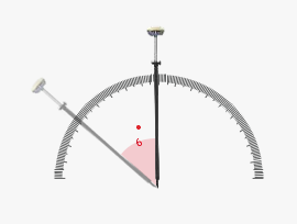
Built-in IMU compensator, correct the coordinates according to the tilt direction and angle of the centering rod automatically within 60°, assist you quickly and accurately survey or stake out points without levelling the pole, improve working efficiency by 20%.
Satellite signals tracked simultaneously | |
Signal tracking | Multi-frequency |
GPS: L1, L1C, L2C, L2P, L5 | |
GLO: G1, G2, G3 | |
BDS: BDS-2: B1I, B2I, B3I BDS-3: B1I, B3I, B1C, B2a, B2b* | |
GAL: E1, E5A, E5B, E6C, AltBOC* | |
QZSS: L1, L2C, L5* | |
SBAS: L1* | |
IRNSS: L5* | |
MSS L-Band (Reserve) | |
Positioning output rate:1Hz~20Hz | |
GNSS features | Initialization time: <10s |
Initialization reliability: >99.99% | |
Positioning precision |
|
Code differential GNSS positioning | Horizontal: ±0.25m+1ppm Vertical: ±0.50m+1ppm |
SBAS positioning accuracy: Typically<5m 3DRMS | |
Static GNSS surveying | Horizontal: ±2.5mm+0.5ppm Vertical: ±5mm+0.5ppm |
Real-time kinematic surveying | Horizontal: ±8mm+1ppm Vertical: ±15mm+1ppm |
Network RTK | Horizontal: ±8mm+0.5ppm Vertical: ±15mm+0.5ppm |
IMU tilt angle | 0°~60° |
User interaction |
|
Operating system | Linux |
Buttons | One button operation |
Indicators | Four indicate lights |
Web UI | Freely to configure and monitor the receiver by accessing to the web server via Wi-Fi and USB |
Voice guide | iVoice intelligent voice technology provides status and voice guide |
Supporting Chinese, English, Korean, Russian, Portuguese, Spanish, Turkish and user define | |
Secondary development | Providing secondary development package |
Hardware performance |
|
Dimension | 135mm(Diameter)x84.75mm(Height) |
Weight | 0.97kg (battery included) |
Material | Magnesium aluminum alloy shell |
Operating | -45°C~+70°C |
Storage | -55°C~+85°C |
Humidity | 100% Non-condensing |
Waterproof/Dustproof | IP67 standard, protected from long time immersion to depth of 1m |
IP67 standard, fully protected against blowing dust | |
Shock and vibration | Withstand 2 meters pole drop onto the cement ground naturally |
Power Supply | 9-28V DC, overvoltage protection |
Battery | Internal Li-on, 6800mAh, 3.7V |
Battery life | Static mode 15 h, Rover mode 14h,Base mode 14h |
Communications |
|
I/O port | 5PIN LEMO external power port + RS232, 7PIN external USB(OTG)+Ethernet |
1 radio antenna interface | |
Wireless modem | Built-in radio, 1W, typically work range can be 15KM |
Radio repeater | |
Frequency Range | 410-470MHz |
SIM card | 4G cellular module standard, customizable 5G module |
Communication Protocol | Farlink, Trimtalk450s, SOUTH, HUACE, Hi-target, Satel |
Double Module Bluetooth | BLEBluetooth 4.0 standard, support for android |
Bluetooth 2.1 + EDR standard | |
NFC Communication | Realizing close range (shorter than 10cm) automatic pair between receiver and controller |
(controller equipped NFC wireless communication module needed) | |
WIFI |
|
Standard | 802.11 b/g standard |
WIFI Hotspot | The WIFI hotspot allows any mobile terminal to connect and access to the internal web server for the control |
and moditor receiver | |
WIFI data link | To work as the datalink that receiver is able to broadcast and receive differential data via WIFI |
Data storage/ Transmission |
|
Data Storage | 8GB SSD internal storage |
Support external USB storage and automatical cycle storage | |
Changeable record interval, up to 20Hz raw data collection | |
Data Transmission | USB data transmission, supporting FTP/HTTP data download |
Data Format | Differential data format: RTCM 2.1, RTCM 2.3, RTCM 3.0, RTCM 3.1, RTCM 3.2 |
Output format: ASIC (NMEA-0813),Binary code (SOUTH Binary) | |
Network model support: VRS, FKP, MAC, fully support NTRIP protocol | |
Inertial sensing system |
|
Tilt angle | Up to 60 degrees |
Electronic bubble | Controller software display electronic bubble, checking levelling status of the centering rod real time |
Thermometer | Built-in thermometer sensors, adopting intelligent temperature control technology which can monitor and |
adjust the temperature of receiver in real time | |
Do you have a question?
min 10 ch