Large room? No right angles? Skewed walls? Many details? Difficult to reach? No cause to worry: The Leica 3D Disto measures everything you need. Ladder? Mobile access platform? You can leave them back at base. No tripod on hand? Makes no difference – simply place the 3D Disto on a table or the floor. Levelling up? Not necessary. Photographs for the records? No problem, the in-built camera provides the pictures.
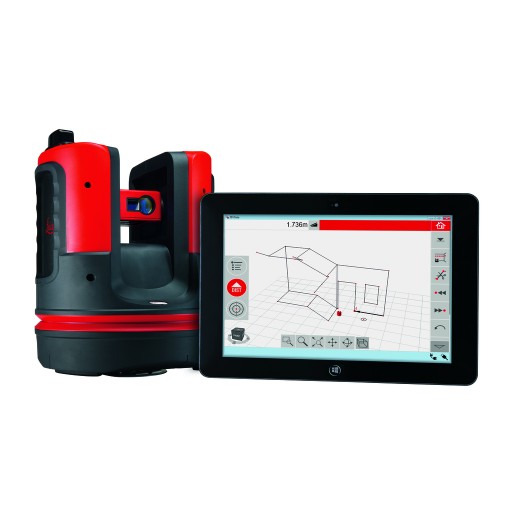
The Leica 3D Disto is a robust, precisely manufactured measuring instrument. A highly accurate combination of distance and angle measurements determine the precise position of each point targeted with the integral camera and captured with the laser beam. In short: the Leica 3D Disto detects the location and the height of the target point.
 | Leica 3D Disto Stay in control - in whatever shape of room. Capture and record distances, areas, inclinations, and angles effortlessly, even for inaccessible points. Forgotten measurements and handwriting errors are things of the past. |
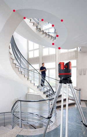
 | Room scan Whether in fully automatic or manual mode: you can measure complete rooms, walls, windows, structural connections or stairs – from only one station point. |
 | Projector Right to the point. Whether ceiling grid or project layout for floors or walls – the Leica 3D Disto projects your design onto any surface – point for point. |
 | Tools Quick tools inspire the user: establish plumb, create level reference points, or precisely transfer offsets or locations. |
| It can do everything | |
|  |
| Product Information | |
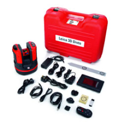
Delivery package: Art.No. 784357
|  |
| Technical specifications | ||
| Features of goniometer (Hz/V) | Range of measurement | Horizontal 360°; vertical 250° |
| Accuracy | 5˝, equates to 1.2 mm @ 50 m | |
| Features of laser distance meter | Type | Coaxial, visible red laser |
| Range of measurement | 0.5 — 50 m | |
| Laser class | 2 | |
| Laser type | 650 nm; < 1 mW | |
| ∅ laser dot (at distance) | 10 m: ~7 mm × 7 mm 30 m: ~9 mm × 15 mm | |
| Tie distance accuracy (3D) Combination of angle and distance | @ 10 m @ 30 m @ 50 m Approx. 1 mm 2 mm 4 mm | |
| Tilt sensor | Self-levelling range | ± 3° |
| Accuracy | 10˝, equates to 2.5 mm @ 50 m | |
| Digital pointfinder | Zoom (magnification) | 1×, 2×, 4×, 8× |
| Field of view (@ 10 m) | 1×: 3.40 m × 2.14 m 2×: 1.70 m × 1.07 m 4×: 0.85 m × 0.54 m 8×: 0.42 m × 0.27 m | |
| Circular level setting accuracy* | 1°/mm | |
| Operation | Screen | High-resolution screen, 800 × 480 pixels, 4.8" TFT LCD, 16 million colors |
| Keys / user interface |
| |
| Memory | Flash memory 32 GB | |
| Interfaces |
| |
| Communication | Cable | US B: Micro-B US B and type A, WLAN |
| Wireless | SD card, range: 50 m (depending on environment) | |
| Data format | Import DXF; export DXF, TXT, CS V, JPG | |
| Power supply | Type |
|
| Operating time | 3D Disto: 8h Hand-held unit: 6h | |
| Attachment | 5 ⁄ 8" thread | |
| Dimensions (W×H×D) |
| |
| Weight |
| |
| Environmental conditions | Operating temperature range |
|
| Storage temperature |
| |
| Water and dust protection |
| |
| Moisture | Max. 85%, non-condensing | |
| Remote control (IR) | Range | 50 m (depending on environment) |
| Communication | Infrared (IR) | |
| Battery | 1 AA , 1.5 V | |
| * Accuracy is specified at 20°C. | ||
Do you have a question?
min 10 ch