


F90 GNSS / RTK RECEIVER
Geneq - F90
- SXblue - F90
- Multi-frequency with L-Bande (RTX) et SBAS
- 336 channel for all GNSS constellation tracking
- 4G cellular connectivity or RX/TX long range UHF radio
View QuoteBuy nowInstant online purchase
Get our best quote for one or multiple products.
Why buy from Geneq? - find out more
The GNSS-RTK Rover F90 offers incredible performance in all conditions. Its compatibility of connectivity to RTK or satellite corrections allows you to work without geographical restrictions
Innovative design and lots of power
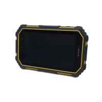
Without affecting accuracy and efficiency, the GNSS-RTK F90 is extremely lightweight and compact even with its magnesium alloy case. Port covers prevent infiltration of water and dust. The design of the port inserted under the outer casing avoids damaging it if it falls. Symbols that clearly indicate the function of the different ports are used to avoid erroneous connections.
Applications
With multiple connectivity options and Web UI control, it offers the user great efficiency and flexibility in the field. Also, its operating system allows management via the Web user interface. Moreover, its use with FieldGenius data collection software maximizes its functionality and propels the F90 to the top of the GNSS-RTK Smart Antenna.
Accuracy and efficiency
Equipped with 2 hot-swappable lithium smart batteries, the F90 can run up to 10 hours without stopping. These batteries are also compatible with the SXPad 1000p. This maximizes energy consumption. Even in the presence of obstacles such as partial vegetation cover, its efficiency is amazing and surpasses the previous generation of GNSS-RTK Rover.
Specifications
- GPS, GLONASS, Galileo, BeiDou, QZSS et SBAS.
- Multi-frequency: L1-L2-L5.
- Bluetooth connectivity is compatible with Android and Windows operating systems.
- 1 cm RTK accuracy (UHF radio ou network).
- RTX (L-band) correction compatible
- 8GB SSD internal memory for GNSS observations recording up to 50 Hz
- Electronic bubble.
| Receiver Model | CY-F90 Multi-frequency |
| Satellites Tracked | GPS: L1 C/A, L2C, L2E, L5 GLONASS: L1 C/A, L2C, L3 BeiDou: B1/B2/B3 Galileo: E1/E5 AltBOC/E5a/E5b/E6 QZSS: L1C/A, L1C, L2C, L5 |
| SENSOR | |
| Operation system | Linux |
| Internal Memory | 8 Gb SSD, expandable up to 32 Gb with CF card |
| Chanel | 336 |
| SBAS | 3 satellites parallel tracking (WAAS/EGNOS/MSAS/GAGNAN) |
| L-Band - RTX | Single-channel |
| Position rate | 50 Hz |
| Δ Autonomous | 1.2 m HRMS 95% confidence1 |
| Δ DGPS (SBAS) | 60 cm HRMS 95% confidence1 |
| Δ RTK | 8 mm + 1 ppm HRMS 95% confidence1 |
| Cold start | 60 sec (typical no almanac or RTC) |
| Signal Reacquisition | 1 sec |
| Static Accuracy | horizontal - 2.5 mm + 1 ppm (RMS) vertical - 8 mm + 1 ppm (RMS) |
| RTK Accuracy | horizontal - 5 mm + 1 ppm (RMS) vertical - 15 mm + 1 ppm (RMS) |
| Differential Option | SBAS, DGPS, L-Band (RTX),RTK |
| COMMUNICATION | |
| Bluetooth | V2.1 + EDR / V4.1 dual-mode; class 2 |
| Bluetooth Compatibility | Windows, Android |
| WIFI | Standard 802.11 b/g/n |
| Web UI | Upgrade software, Manage Status and Settings, Logging and download data |
| 4G | EC25-E, EC25-A : LTE, WCDMA, GSM |
| Internal UHF radio | TRM 101: 1 Watt; Frequency: 410-470 MHz; Protocol : Satel, PCC-GMSK, TrimTalk 450S, South, TrimMark III |
| Internal Sensor | Electronic bubble |
| I/O Data Format | NMEA 0183, RTCM 104, binary |
| RAW data observation | Binary (free RINEX converter) |
| I/O correction format | RTCM 2.x, RTCM 3.x, CMR, CMR+, RTCA |
| LED indicator | Power state, Satellite tracking, Differential transmission, Bluetooth |
| INTERFACE | |
| TNC | UHF Antenna |
| Lemo 5 pins | External power and radio |
| Lemo 7 pins | USB port; NMEA output |
| Card compartment | Micro SIM and TF card slot |
| POWER SUPPLY | |
| Battery | 2 rechargeables and replaceable intelligent Lithium-ion |
| Capacity | 3400 mAh, 7.2 volts |
| Working time | 10hr |
| Voltage | 9-28 Vcc |
| ENVIRONMENT | |
| Operating temperature | -30°C to +65°C (-22°F to +149°F) |
| Storage temperature | -40°C to +80°C (-40°F to +176°F) |
| Humidity | 100% non-condensing |
| Certification | FCC, CE, RoHS and Lead-free |
| MECHANIC | |
| Enclosure material | Magnesium alloy body |
| Enclosure rating | IP67 dust and waterproof |
| Dimensions | 15.7 cm x 7.6 cm (6.18 in x 3.0 in) |
| Weight | 1.2 kg (2.65 lbs) with 2 batteries |
| Resistance | Vibration resistant and 1.2 m pole drop |
1. Depends on multipath environment, number of satellites in view, satellite geometry, baseline length (for local services) and ionospheric activities. Stated accuracies for baseline lengths of up to 50 km.
2. Lithium-ion battery performance degrades below -20 °C (-4 °F).
Do you have a question?
min 10 ch